The Nicoya Seismic Cycle Observatory (NSCO): Capturing the evolution of the subduction megathrust.
The Nicoya Portion of the Middle America Trench Interface has undergone large earthquakes, greater than about magnitude 7.5 approximately every 50 years, with the most recent occurring in September of 2012.
Spurred by research funding through the US National Science Foundation's MARGINS program, a number of studies have investigated the geologic and geophysical characteristics of this environment over the decade before the 2012 earthquake. As a part of this work researchers have been able to map out the seismic and geodetic (deformation) characteristics of a subduction megathrust environment during the late-interseismic period.
With a small additional grant from the NSF-RAPID program, geodetic and seismic operations have continued following this earthquake, helping to capture both the coseismic and early postseismic character of this event.
The question remains, "How do subduction megathrusts transition from the very weak coseismic and early postseismic period, back into a regime that locks up again to store energy for the next big earthquake?". This question is both of scientific interest and important for understanding long-term earthquake hazards. The process is a fundamental, yet poorly understood component of earthquake and fault mechanics that may be affected by each mineral properties, stress-level, fluid saturation, and thermal state. Imaging this process gives boundary conditions for a number of models that aim to explain the process. For hazards, this image is equally important. Subduction zones are generally very weak environments, usually with only between 10 and 50% of their potential tectonic strain released in large earthquakes. Because the seismic potential is weak and poorly understood, it is very difficult to directly associate long-term tectonic loading rates directly to future earthquakes (affecting their magnitude, and recurrence interval). However, if we can image exactly when and where an environment changes from weak (and slipping) to strong (and locked) then we can better understand the true strain potential, and come at more accurate assessments of the potential for damaging earthquakes.
The NSCO is ideally situated to illuminate this early transition from post-seismic slip to interseismic strain accumulation.
 |
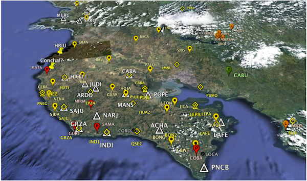
| GoogleEarth image of the NSCO network as it existed during, and immediately following the 2012 Nicoya Earthquake. The network consists of 17 Continuous and 24 Survey GPS sites (pins), and 16 mostly broad-band seismic sensors (triangles). |
more to come...


